Tuesday, November 30, 2010

Wakatobi National Park Adventure And Diving

The Wakatobi National Park (WNP) marine protected area (13,900 km2) was formed in 1996, and includes the atolls and islands of the Tukang Besi Archipelago. The support for the formation of WNP was based on the park’s position in the centre of the Wallacea Region — a biodiversity ”hot spot”2,3,4, and the relatively low level of subsistence and commercial fishing on the 50,000 ha of coral reef within the park. Since its wellintended start, WNP languished as a paper park, suffering from a lack of funding, continued destructive fishing practices, and complacent park rangers and management (Elliott et al. 2001; Clifton 2003).

Furthermore, there has been limited success in addressing the dipolar needs of expanding local resource use and centralised WNP management objectives. In 2003 a new Head of WNP was appointed and WNP was selected for the Indonesian government’s Coral Reef Rehabilitation and Management Program (COREMAP), which aims to develop co-management of reef fisheries in Indonesia. Since 2001, Operation Wallacea has examined various aspects of fisheries around Kaledupa, as part of volunteer programmes, and as ongoing monitoring studies. This work is being put forward as part of a fisheries co-management programme evolving from the WNP, COREMAP and TNC/WWF.

History and Culture

Within WNP there are two socially-segregated ethnic groups: the Orang Bajo (Bajo People), who speak Bahasa Sama, and the Orang Palo (Island People), who speak Bahasa Pulo. Originally, the Bajo were sea nomads living on boats throughout the Malay Archipelago, whose livelihoods and culture were based on subsistence fishing (Djohani 1996; Sather 1997). The Palo are decedents of nearby ethnic Butonese and were predominantly land dwellers, practicing both fishing and farming. In addition the Palo have a strong maritime history as sea traders and pirates, possessing many large wooden sail boats called sopes (Schoorl 1986), which traditionally formed the bulk of the Sultan of Buton’s fleet.

However, these seemingly unassociated ethnic groups appear to have cohabited the area, as flood stories
in both folk histories tell of a split in one people, the Bajo travelling far out to the sea and the Palo climbing the highest peaks.

Adventure And Diving

Bajo and Palo fish folk taxa were collected during creel and onboard surveys of all fishing techniques
used on the reef flat, crest and wall in the waters around Kaledupa Island between 2001 and 2004. Fish names were re-corrected for misidentification and pronunciation initially, and where confusion arose, fishers were interviewed for clarification. All interviews were conducted in fishers’ respective languages with experienced interpreters.

During all interviews, folk taxa were checked using the illustrations in Allen (2000) and Lieske and Myers (1996), and photographs in Allen et al. (2003). If there was no general consensus for a species-specific folk taxon, only well known folk taxa for the generic groups were recorded. Most common English names were
taken from Allen (2000), as it was found to be very comprehensive for WNP, good for identification of most species, and easy to use for referencing. Etymological translations were obtained from local Bajo and Palo translators who worked closely on fisheries surveys between 2001 and 2004.

During creel and onboard surveys, 313 species of bony fish (dayahb: kentap)5 were recorded, for which
229 individual Bajo and 199 individual Palo folk taxa were identified (Appendix I). There were around 40 commonly caught species that most fishers could readily identify, beyond which identification became ambiguous. Consequently, the folk taxa displayed in Appendix I represent the collective knowledge of fishers, not the general ability of fishers to identify folk taxa, which improved with age and fishing experience.

Generic group lexemes were defined as those identified by fishers to have an appreciated generic value, though not necessarily with a known translation. There are 53 and 54 generic group lexemes that represent 43% and 40% of the caught species in Bajo and Palo, respectively. A further 8% and 3%, respectively, of
caught species appeared to have generic values that were not identified by fishers. The use of speciesidentifying primary lexemes generally corresponds to species with clearly identifying features and does not appear to be related to locally desirable species.

However, identification of infrequently caught nontarget species (i.e. damsel fish), was not possible below generic groups, mostly because fishers’ appeared to have little interest in such species.

Friday, November 19, 2010

Tarsius Viewing Range Tangkoko National Park Native In Sulawesi

History Tangkoko National Park and Tarsius Spectrum

Trace the history, in this Tangkoko National Park Alfred Russel Wallace set foot in the 1850s. That said, this great scientist fascinated with the Maleo and Babi Rusa. As information, from exploring the archipelago around 1850 until the 1860s, he observed that based on the spread of wildlife there are large differences between India and Australia. That's why Wallace made imaginary line became the boundary between west and east, starting from the strait between Kalimantan and Sulawesi, continue south in the strait between Bali and Lombok.

 This imaginary line known as the Wallace Line, which distinguish the various species in the west and the east side. Later, the letters and papers sent Wallace to Charles Darwin in the UK, spurred Darwin to write the Origin of Species as the embryo of the theory of evolution.

If you want to visit the Tangkoko National Park, you better get there after 3 pm. Because at that hour this afternoon will be easier for you if you want to see Tarsier, the smallest primate in the world. Actually not only Tarsius in this national park. According to records, there are 26 species of mammals, 180 species of birds and 15 species of reptiles and amphibians.


Shortly after we entered the forest area, we were greeted by the monkey Macaca Nigra, or Black Sulawesi or Yaki in the local language. This is the Tarsier, Tarsius Spectrum with its Latin name, species endemic to Sulawesi, which you will not find on other islands. It belongs to a nocturnal animal, which used to operate in the stillness of the night foraging.

The food is fruit and small insects, usually live clustered in tree holes. Satisfied Tarsier watching and taking pictures we were heading back home to enter. Apparently a different route when we came in, we have to pass Coast Tangkoko that looks beautiful with his trademark black sand beach.


Tuesday, November 16, 2010

KAKABAN ISLAND And JELLY FISH In Borneo

Diving Kakaban Island Or Kakaban Lake


Kakaban lake Or Kakaban Island formed from a ring-shaped coral islands called atolls. Generally, land atoll measuring sea surface narrow and circular. In the middle of the atoll there is such a pool containing sea water called a lagoon.

The sunny morning and the weather is so cool, we went aboard the boat that we ride straight to the Barracuda Point Kakaban Lake. Dive profile today is a beautiful wall with gentle flow toward the tip of the island where we all have to turn so as not to carry over into the high seas. The second time we also see schooling barracuda, but not as much that is in Maratua.

Kakaban Jelly fish
We also saw leopard sharks were relaxing fun on the white sand, which is said if we can make it convenient, it can be embraced and leopards in a photo together. After finishing the first dive, we were all close to the existing pier at Kakaban Lake, to go to Jellyfish Lake. WONDERFUL, the first word that we say after seeing an isolated brackish water lake in the middle Kakaban Island. The lake is inhabited by thousands of non-sting Jelly Fish (Jellyfish) Jellyfish jellyfish which we can touch without any shock. It is said the lake like this there are only 2 in the world other than in Palau.

Diving And Trip Maratua Island Borneo

Maratua Island

The Light House, that's the first point that we dive into the day. Shortly before arriving at the dive location, the lighthouse was visible amid towering green Maratua island cliffs. Perhaps, if lucky we could dive with Dolphin here. Dive began, along a beautiful wall and vizibility good enough at that time.

The second dive we did in 'The Channel' or say that the point of 'Big Fish Country'. After waiting for high tide, we all rushed down the entrance channel Maratua Island then energized hard enough. But precisely these currents that make the big fish fro in front of us. From Giant Trevally, Shark Grey, white tips sharks until schooling Barracuda all we can see here and click amazed invite colleagues from around here. After the flow was thrown hard enough as a safety stop, we all end very memorable diving in the day.


Sangalaki Island In Borneo

Sangalaki Island

Your Adventure Experts Island Dreams' Ken Knezick was involved in the first American familiarization trip to Sipadan, and has been representing Borneo Divers continuously since 1989. In 1992, Borneo Divers' Ron Holland invited Ken on an exploratory expedition to the then undeveloped island of Sangalaki and its sister island of Kakaban, off the coast of Indonesian Borneo.

They camped out in relatively primitive conditions, but what they saw was more than enough to convince Borneo Divers to develop a dive resort there. The partnership has since changed hands but Sangalaki Diving Lodge remains. Sangalaki is the world Capital of Mantas. At Sangalaki Diving Site the familiar set of Manta Rays emerges from all directions. Their wing tips breaking the surfaces at regular interval.

Snorkelling is the way to interact with this gentle plankton feeders. Totally unperturbed by your presence, they swim in eurythymy and sometimes glide right up to you before making a sharp nose-dive into the blue. It is not unusual to find them encircling you.

Though most of them are about 3,5 meters (12 ft) wide with a white belly, there a few black giant with a 6 meters (20 ft) wing span - we refer to them fondly as the Darth Vaders.
Located 90 miles from Tarakan, East Kalimantan, Indonesia, and lying just two degrees above the Equator, the island of Sangalaki is clothed in dense jungle forest surrounded by white sandy beaches. Shallow reefs extend out 600 meters from shore.

The soft, sandy beaches with tropical undergrowth provide the perfect natural site for turtle egg laying. As a result, Sangalaki is a prolific turtle breeding area. You will have the opportunity to see mating activity, nesting, egg laying, and baby hatchlings making their way back into the sea, completing the cylce of life. Anyone interested in wildlife will find this a truly unforgettable experience.

Sangalaki is also a breeding ground for manta rays, and sightings are a daily occurrence. It's also common to see eagle rays, sting rays, giant green turtles, leopard shark, cuttlefish, and all manor of the Indo-Pacific realm's dazzling array of tropical fish, hard and soft corals, and invertebrate life. The nearby island of Kakaban adds to the variety with a profound wall dive and its own diverse array of marine life. To complete the attraction, Kakaban's interior contains a unique jellyfish lake. Similar to the one in Palau, it is home to millions of (non-stinging) jellyfish and a host of other exotic life, including some species found no where else in the world.

Due to its unique location, a visit to Sangalaki can be accomplished in conjunction with a trip to Mabul, with exciting land touring options available throughout Borneo and Malaysia. It can just as easily be made a prime component of a trip to Bali and Indonesia. In either case, the traveler must make their way to the International Airport at Balikpapan, the major city on the Indonesian state of Kalimantan. From there, a representative will assist with the small plane flight continuing on to coastal city of Tanjung Redeb in the Berau district. In some cases, flight schedules will necessitate an overnight in Balikpapan.

The price for a week at Sangalaki is $1750 per person. This includes the boat transfer from Berau, 7 nights lodging, hotel tax, all meals, three boat dives per day, and two boat night dives per week. This price is based on four or more guests transfering at the same time, in each direction. Custom transfers, for less than four people, are at additional expense.


Airfare and any lodging on the mainland is additional. Island Dreams can assist you with your international flights, as well as the domestic air arrangements to Berau. We have years of experience, and the knowledge to help you learn more about Sangalaki, Indonesia and Malaysia. Call or E-mail to receive a free information package. Start planning YOUR ultimate dive adventure...contact Island Dreams today!

Sangalaki-Derawan Island Map

Adventure and Trip Orang Utan in Tanjung Putting National Park Kalimantan

KTanjung Puting Natioanal Park Orang Utan

Wildlife Adventure Tour "The Forest" Tanjung Putting National Park is the most popular tourism objects and is very popular in Central Kalimantan. In this tourist Tourists can see directly the jungles of Borneo's wildlife is a close look at the life of Forest People (Pongo Phymaeus), Bakantan (Nazalis Larvatus), Owa-owa (Hylobates Agili), monkey (Macaca Fascicularis) and many other forest animals such as the Warthog, Honey Bear, Crocodile, hornbills, Eagles etc.


The journey begins from Palangkaraya to the city of Pangkalan Kotawaringi Regency West, can be reached by land vehicle (car) about 11 hours traveling through the City Kasongan and Sampit or using the Aircraft (45 Minutes) further from the city of Pangkalan Bun go from here Kumai District followed by a tour boat trip (kelotok) leading to the Tanjung Putting National Park.

Furthermore, from the port of Kumai journey continues towards Tanjung Putting National Park after first completing the administrative offices Located TNTP and report themselves to Police for Foreign Tourists. If the journey starts right time (12.00 am Afternoon Hours) from Kumai then the tourists will be able to see the person directly Forest and near the Cape of Good Hope at 15.00 pm when the park officials to provide food (fedding time) journey from the port of Kumai taken towards Cape of Good Hope for 1.5 hours along the beautiful River Sekonyer.

Adventures of Wild Nature "Orang Utan"

Wildlife Adventure Tour "The Forest" Tanjung Putting National Park is the most popular tourism objects and is very popular in Central Kalimantan. In this tourist Tourists can see directly the jungles of Borneo's wildlife is a close look at the life of Forest People (Pongo Phymaeus), Bakantan (Nazalis Larvatus), Owa-owa (Hylobates Agili), monkey (Macaca Fascicularis) and many other forest animals such as the Warthog, Honey Bear, Crocodile, hornbills, Eagles etc.

The journey begins from Palangkaraya to the city of Pangkalan Bun Kotawaring Regency West, can be reached by land vehicle (car) about 11 hours traveling through the City Kasongan and Sampit or using the Aircraft (45 Minutes) further from the city of Pangkalan Bun go from here Kumai District followed by a tour boat trip (kelotok) leading to the Tanjung Putting National Park.

From the Cape of Good Hope the journey continues to see several groups Bakantan're chatting and getting to sleep in a tree-lined river ditepian Sekonyer then wisatan will rest in Rimba Orangutan Ecolodge (Hotel Wilderness). Rate room at this hotel starting from Rp. 500.000, - to Rp. 900.000, - / room / night with a choice of rooms Emerald, Sapphire, Ruby with a choice of hot water facilities, air conditioning and Fan.

On the morning after sufficient rest at Rimba Lodge Pondok Tanggui adventure continues into the wild to see the activities of forest People at Feeding Time, 09:00 pm. The journey taken for 1 Hour and 15 Minutes Tracking in the forest to where the officer TNTP provide food.

From Cottage Tanggui Sekonyer proceed down the river upstream to where Feeding Time at Camp Leakey, in this place since Sekonyer down the river you'll be greeted by various kinds of wild animals that roost in trees at the port stops kelotok at Camp Leakey you will be lucky if Forest People immediately greeted by a benign with its hospitality.

Monday, November 15, 2010

Solo Batik

Solo Batik In Central Java

Solo Batik is famous for its style and its traditional batik pattern in the stamp and in the process of batik he wrote. The materials used for staining still remains a lot of use of domestic materials such as Java soga already known since the first. The pattern remained among others, famous for "Sidomukti" and "Sidoluruh".

Laweyen is one of the central Batik in Solo. Surely this village there are a lot of history left in this vilage and became icons Batik Solo.


Sunday, November 14, 2010

Adventure At Cave Ningrong Yogyakarta

Cave Ningrong in Indonesia Gua Ningrong

Besides having many beautiful beaches tour, turned out to Gunung Kidul area has many caves, more or less 10 caves over one of them Ningrong. This cave is also still in the area of Gunung Kidul regency, Yogyakarta.

 Cave which has a diameter of 10 meters, height of this cave ceiling to 40 feet with a width of approximately 20 meter. Ningrong Cave is located in a large valley on the edge of the highway is known as a cave with a varied terrain and stunning scenery, because not only the horizontal and vertical streets. Here too there is a vast lake, not half-hearted 3 pieces lake in it. Area of lake is approximately 10 x 20 meters.

To enter this cave we also have to have the equipment required to complete such as the Cave Jati I've ever written before. The cave is located in a large valley on the edge of the highway is known as a cave with a varied terrain and stunning scenery, because not only the horizontal and vertical streets. Here too there is a vast lake, not half-hearted 3 pieces lake in it.


Equipment that must be prepared

Wearing overalls, headlamp and carbide bomb as a means of illumination, SRT equipment, and additional buoys.

Root Bridge

Root Bridge Or Indonesia Jembatan Akar

This bridge is called the root bridge because made of two roots of trees which in the form of small-d above which the river naturally. This bridge is located 70 km south of Padang.

 This bridge is a walk from the beach in the direction after passing through the bay bayur Painan, New Hampshire, U.S. road trip, play some hills and down to the beach again following the creek bends. On the long road and pedestrian bridges in the wake residents to cross the river, really impressive.

In addition, Unique other  is the increased strength of the bridge along with increasing age of the bridge. This is different from ordinary bridge the longer days will be increasingly vulnerable.
With a length of 25 meters, root bridge is longer than the root bridge on the Bedouin, West Java and the roots of the existing bridges in Japan.

The root bridge is estimated to have about 100 years old. The bridge was built by assembling the roots of two tree species, each of which grow on both sides of river. Type of tree are kubang tree (ficus sp) which usually grow in the vicinity of the river where the root bridge is rebuilt.

That said, the bridge was designed by a scholar named Pakih Sokan. Construction of the bridge as part of efforts to link the two villages are separated by a river. Construction of the bridge began in 1890 and can be used by the local society in 1916. In other words, the roots knit into this bridge needs less than 26 years. (See Also Root Bridge in India)

Sightseeing is located approximately 88 km south of the town of Padang, precisely in the District of Bayang, South Coastal District, West Sumatra.

Access to the Root Bridge attractions can be reached by using public transportation, travel, rental car or private car. If using public transport, the journey begins from the town of Padang to Painan (district capital). Then, from Painan journey continues into the district. Shadow. If the tourists using the car sewan or private cars can go straight to the location of a tourist attraction.

Not so much a tourist attraction city Painan (district capital), for the tourists who come from out of town can stay at hotels and resorts in the city. In this city there are also many restaurants
In this tourist attraction, there are several small shops that provide soft drinks and instant noodle. It's good for the tourists bring their own food supplies to be enjoyed under the shade trees around the site a tourist attraction

Maninjau Lake Trip In Sumatera

Maninjau Lake In Indonesia Danau Maninjau

Maninjau Lake is one of the lakes located in the Province of West Sumatra, this lake is one example of the lake that has a multifunction that is as power plants (hydropower), fishing activities (business floating cage / cage and fishing), tourism activities, irrigation, and others. So economically surrounding communities

Highly dependent on the lake either directly or indirectly. In its development activities caused a decline in function of the lake, so we need a study limnologis to get a picture of the processes of physical-chemical-and biological changes that occur in Maninjau Lake.

This becomes very important as a basis for making decisions about the sustainable management of Lake Maninjau. In the Year 2008 Maninjau Lake Limonology study conducted with an emphasis on some basic issues such as sulfur biogeochemical processes occurring in the lake, continued monitoring of chemical parameters, physical and aquatic biology, and the efforts of domestication and development of native fishes of Lake Maninjau.

Research carried out by means of surveys (primary data) and secondary data collection. The results of several parameters show conditions in the waters of Lake Maninjau eutrophik mild conditions. Areas that have a cage culture activity to be seen the condition of the quality of waters, because the pressure will increase with the increased activity cage.


Type: Lake Tectonics
Location : Agam District, Padang, West Sumatra.
Height: 461.5 m above sea level.
Size : 96 Km2
Depth max. : 165 m

Trip Mentawai

Mentawai Island

The beauty of the Mentawai Islands was remarkable. Extend the white sand, blue sea decorated with coral reefs. You could say, Mentawai is one of a paradise for surfers. While exotica was coupled from the Mentawai Tribe tattoo art is legendary in the world.

Siberut Island is the main island in the Mentawai. The island is reached by ferry for 10 hours from Padang. The island has become the most crowded population activities. Meanwhile, there are many interesting places such as Pulau Botik with white sand and rocks.

A number of resorts scattered around the Mentawai be evidence of high interest to the foreign tourists in the Mentawai. Most of the surfers who hunt waves to conquer.

Now, about the settlement, the Mentawai tribe lived somewhat in the island. But indeed many Mentawai people who live on the seafront.

Mentawai Surfing The Best in Worlds
If heavy rain plus high tides, water easily went up to the land until the calf. But if until the tsunami hit, then do not imagine the impact that received this beautiful archipelago. Mentawai also become a means of surfing the most beautiful in the world with waves waves are quite strong.

Mentawai Tribal

Saturday, November 13, 2010

Tabuhan Cave Trip East Java

Tabuhan Cave In Indonesia Gua Tabuhan

The Tabuhan cave is located in the village wasp Warreng Donorojo district is named as stalactites and stalagmites wasp when beaten off, and when beaten in rhythmic accompaniment will be a beautiful music or musical instrument Java. This makes the main attraction of the artists, so they sometimes hold an arts degree. In addition, many historic and prehistoric relics found here.


Luweng Jaran Cave East Java The Worlds Longest

Luweng Jaran Cave Or In Indonesia Gua Luweng Jaran

 For those of you who have an adventurous spirit, sights on this one suits you went to, the cave Luweng Jaran. Luweng Jaran is the longest cave in Indonesia. In 2002 Luweng Jaran Cave registered in the list of longest caves in the world with a total length reaches 24 km.

Jaran Luweng Jlubang located in the village, Kec. Punung, Pacitan, East Java. Was first discovered by local residents, then in the first exploration by the Joint Expedition team Anglo - Australian, who was accompanied by a crawler Caves of Indonesia in 1984.

Navigate the necessary equipment is a vertical cave, first pitting dg 12 meters depth, to the first terrace with a distance of about 25 meters before reaching the second wells with a depth of 25 meters after pitting the two, there is a very large hall, began here can be done without equipment field vertically. Advised to bring a map of the cave or leave the marker so as not to get lost in search activity in this cave.

 In addition, this cave is very dangerous in the rainy season, because it is a place Swallow Hole or disappearance of the river surface into the cave. Not a few who get caught flooding cave crawler in this cave.
For the sake of safety and security, tourists must obtain prior consent from the local Office of Culture and Tourism.

Gong Cave Trip To Eastern Java in Pacitan

Gong Cave Shines Like Gold In Indonesia Gua Gong

Gong Cave is situated in the village district Bomo Punung. This cave is one of mainstay attractions Pacitan city. Extensive cave is nearly 500 m square. Access to the cave Gong quite easy, because it can be taken by all types of transportation. Gong cave was first discovered in 1924 by mbah Joyo and Noyo Sumito. At that time, he was looking for water in the dry season.

According Sarwanto, guard  Gong Cave The Gong Cave that named because it was taken from the name of Gong Mountain where the cave is located. It is said that the story before it opened to the public, a voice sounds like a Javanese gamelan Kliwon every Friday night. Either the sound was coming from the water droplets from the stalactite and stalagnite or even come from being fine. In addition, the stalactite and stalagmite in the cave Gong if can hit sounds like the sound of a gong or Javanese Music traditional.

 
Besides having a stalagmite and stalactite are quite beautiful, Gua Gong also has four standing water (people call it by spring.) Sarwanto adding that it is said every Spring it has efficacy and usefulness of its own. Fourth Spring is Spring jampi Rogo (the water is believed efficacious for health and medicine), Spring Kamulyan (efficacious to add kemulyaan), In java Philosophi Spring Jiwo Panguripan and spring recesses. Based on trust, making the water is usually done on Friday night and most major Kliwon Shura month or Java Calendar and Islamic Calendar.


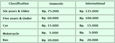
In a day visitor Gong cave about 300 people, when vacations can reach 1000 visitors. Even when the day of Eid could reach 5,000 visitors. Visitors enough to pay USD 4200 for adults, and young children Rp 2700. There is a discount of 20% for groups outside of Pacitan.

Gong Cave

Thursday, November 11, 2010

Trip Taman Safari Indonesia In Bandung west Java

Taman Safari Indonesia

Taman Safari Indonesia (TSI), located in the village of Cibeureum, Kec. Cisarua, Kab. Bogor, West Java, was built in 1980. The location is now occupied, a former tea plantation that is no longer productive. The land area of 138.5 ha by the Local Government handed over to the Oriental Circus for its management.

Taman Safari Indonesia is located in the buffer zone of Mount Gede National Park Pangrango and at an altitude of 900-1800 above sea level, as well as having an average temperature of 16-27 degrees Celsius, has been designated as National Tourism by Minister of Tourism, Posts and Telecommunications, (deceased) Mr. Soesilo Soedarman, and inaugurated the Institute of Ex-situ Conservation and Breeding Centre for Endangered Wildlife in Indonesia by the Minister for Forestry Mr Hasyrul Harahap on March 16, 1990.

Location Taman Safari Indonesia, located on the highway from Jakarta to Bandung, approximately 80 km from Jakarta or from 1.5 to 2 hours by vehicle. Meanwhile, when from Bandung about 78 km or 3 hours by car. When using public transportation / bus from Jakarta and Bandung, stopping at Cibeureum Cisarua, then continued by using a motorcycle taxi or public transportation, more or less 15 minutes to Taman Safari Indonesia.

National Tourism Indonesia Safari Park is a blend of modern zoos and nature tourism, officially opened to the public in 1986. Collection of animals owned at that time only about 250 of the tail consisting of 100 different species. Ten years later, in October 1995, a collection of animals at the Safari Park has 2,500 fish of 200 species. Where 50% of them are animals born Safari Park, the rest is a surrogate species from various relevant agencies, such as PHPA (Forest Protection and Nature Conservation), the transfer from the surrounding community, or accidentally imported from overseas zoo animal exchange program.

The animals in the Safari Park is generally a well protected animals from Indonesia as well as those imported from five continents. Currently there are some tail, the situation is very worrying, so the need for human intervention in increasing its population through a program penangkaran.Taman Safari - Bogor also have a waterfall in it. To visit it should be done by foot (+ / - 500m), since there is no way that can be passed by a motor vehicle to place the location. Not only natural recreation available in the Safari Park. There are many public recreation facilities that can be enjoyed with family.

Just like any other zoo, the Safari Park has several functions. Aside from being a recreational site is also active in helping businesses protect and restore populations of endangered wildlife species due to habitat loss. In addition, increasing scientific knowledge by conducting various studies to support the preservation of wildlife, as well as campaigning, education and counseling about conservation.

Safari Park Ticket Prices 

Wednesday, November 10, 2010

Nusa Dua Beach

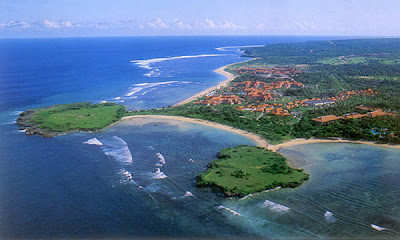
Nusa Dua Beach is located approximately 40 km south of Denpasar, the provincial capital of Bali.

The place name Nusa Dua can be used in two ways: either it can refer to the entire eastern side of the Bukit Peninsula at the southern tip of Bali, or it can refer to the purpose-built, safe and rather sterile tourist enclave (Kawasan Pariwisata, quite literally Tourism District) at the southeast side of this peninsula. 

This article covers everything in the Nusa Dua enclave plus the Tanjung Benoa peninsula and a few points west of the enclave to the village of Sawangan. Everything on the Bukit Penisula to the west of Sawangan is covered by the Uluwatu article. 

As well as a host of luxury hotels, Nusa Dua is home to the most popular golf course in Bali and the main convention centre on the island. 

Nusa Dua understandably gets a lot of bad press amongst travelers as it is so artificial and sanitised. That does not change the fact though that the beaches here are glorious - white sand, deep, long and safe for swimming. The public beach at Geger is the best to head to if you are not staying at Nusa Dua. This is also home to one of the best museums in Bali. The fact that it is nearly always empty is testament that most visitors who stay here in the least Balinese part of the island are, not unsurprisingly, rather disinterested in learning much about Bali. 

The Nusa Dua enclave has three manned gates and everyone entering is subject to a security search. This can have a slightly claustrophobic effect, and only contributes further to the impression that you are in an artificial location. [source : Nusa Dua]

See The Beauty