Showing posts with label Islands. Show all posts

Monday, December 27, 2010

World Class Diving of Alor Island

Alor Island regency is the least visited and therefore the most unspoiled region of Nusa Tenggara Timur (NTT). Trek to the rim of a volcano on Pantar or dive the straits of Alor and Pantar in a dive destination rated by all to be amongst the best in the world. Ponder on the existence of the Moko drums, which are not found in large numbers anywhere else in Indonesia and can be traced back to the Dongson period in Vietnam around 350 BC and you start to realize that Alor is truly a land lost in time.

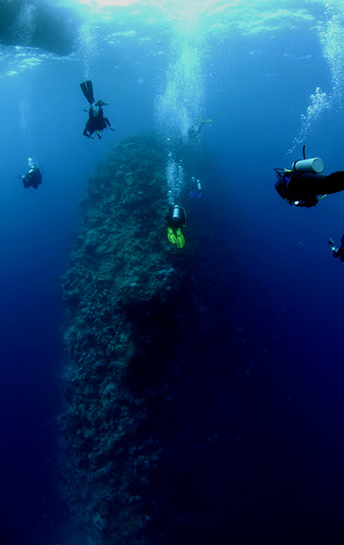
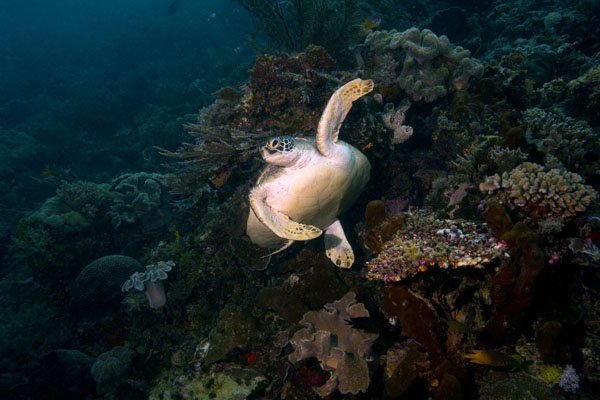
Alor diving is known as the best in the world with its smoldering volcanoes reaching down into crystal clear waters fringed with pristine coral reefs, coconut fringed pure white sandy beaches and traditional villages built half way up mountains, the scenery is as spectacular above as it is below the waterline. Alor Island is so mountainous that it is almost impossible to pass from one side to the other and many of the villages on the island itself can only transport themselves via small wooden ferries. The eight distinct dialects and more than 50 sub-dialects spoken today, testifies to the diversity on Alor. 

Alor traditional culture has been influenced over the ages by the Indian, Chinese and Javanese traders as well as by the Islamic and Christian religions. This can be seen in the silk thread woven into the original weavings and the mix of Mosques and Christian churches dotted throughout the Island. The traditional dances, Ikat weavings motifs and the varies architectural style greatly from area to area. With more than a dozen traditional villages within one hours drive from the capital Kalabahi - Alor is a cultural tourists heaven. [source: Alor]

See The Beauty


Wednesday, November 10, 2010

Krakatau

Krakatau (Indonesian: Krakatau), often mispelled Krakatoa, is a volcanic island made of a'a lava located in South Lampung region in the Sunda Strait between the islands of Java and Sumatra in Indonesia. The name is used for the island group, the main island (also called Rakata), and the volcano as a whole. The island exploded in 1883, killing approximately 40,000 people, although some estimates put the death toll much higher. The explosion is still considered to be the loudest sound ever heard in modern history, with reports of it being heard nearly 3,000 miles from its point of origin. The shock wave from the explosion was recorded on barographs around the globe.

In the early time Krakatau estimated was a volcano with 2000 M in height. The catastrophic eruption destroyed the volcano and remained 3 islands i.e. Rakata, sertung and Panjang. The renewed activity was started at Rakata, and an island of strato volcano was built up with diameter of approximately 5 Km and 800 M high. After its dormancy, next activity was shifted come into existence with the height approximately 456 and 120 M above sea level. In 1883, the 3 summits (Rakata, Danan & Perbuatan) was erupted and leaving a piece of small part of Rakata. The boom of explosion causing tremors and was heard as far as Singapore and Australia. The wave washed everything away around volcano. The volcanic ash was blown in to the atmosphere, as much as 4 cubic miles. In 1927 the new activity was occurred and then Anak Krakatau existed in to being. Now Anak Krakatau has reached 250 meters above sea level. Anak Krakatau still active with its gush of steam and smoke, make it spectacular view.

Today we can come and step our foot on it searching closely the minerals (volcanic bomb, lava, lapel) from the bottom of the earth which were thrown up through its crater. Krakatau and its terrific eruption, which is recorded in the history, now has invites every one to come and see for science as well as for pleasure. The way to get there is from Canti located in Kalianda about an hour driving from Bandar Lampung, and the boats will take to the Karakatau area. Near by the Krakatau there are Sebuku and Sabesi Island as for stopover and staying over night. It is only taken one and half-hour from Canti. [source : Krakatau Tourism]

See The Dangerous Beauty


Thursday, October 21, 2010

Mentawai Islands : World Class Surfers Destination

The Mentawai Islands are a chain of about seventy islands and islets off the western coast of Sumatra in Indonesia. Siberut (4,030 km²) is the largest of the islands. This island is home to a rich array of bio-diversity which has earned it designation as a UNESCO biosphere reserve. The other major islands are Sipura, North Pagai (Pagai Utara) and South Pagai (Pagai Selatan). The islands lie approximately 150 km off the Sumatran coast, across the Mentawai Strait.

Take a trip into the wild with an adventure to the Mentawai islands. Be surrounded by tropical rainforests and immerse yourself in the traditions of the local people. While the physical distance between the mainland and Mentawai is not great, this remains one of the most isolated places in Indonesia, and was only subject to outside influences at the start of the 20th century. A long way from the world of shopping malls and theme parks, this is where travellers come to get a truly off the beaten track adventure.

Mentawai Rain Forest
The remote location of these islands means that the Mentawai people have had very little contact with the outside world. The archipelogo is thought to have broken off from the rest of Sumatra about 500,000 years ago and it is only since the 20th century that outside influences began to have an impact on the local people. Today, the Mentawai still abide by traditional practices and live largely off the land. Local people have a strong spiritual relationship with the forest with a belief system that emphasizes harmony with creation. 

It is believed people first came to inhabit these islands at least several thousand years ago. Most anthropologists classify the Mentawai people as Protomalay which means they have a mostly Neotlithic culture but have not been effected by Buddhism, Islam or Hinduism.

Mentawai Traditional Tattoo
Tatoos are an important symbol in Mentawai culture and reflect maturity, manhood and status. The art of this body painting has been inherited from ancient ancestors and the ink is made from natural fibres.

The biggest town on Siberut is Muara Siberut on the southeast coast. This is the major point of entry for tour groups from the mainland. From here, you can travel with a with a local guide and trek inland to some of the Mentawai villages. If your bahasa is good enough, chat to the locals and enjoy their hospitality.

The biggest attraction for visitors to these islands is the world class surfing. With some of the best surfing conditions in the world, monster waves and swells that remain all year round, this is ranked by serious surfers as a must visit destination.  [source : Mentawai]

See The Beauty

Saturday, August 28, 2010

Bangka–Belitung Islands

Bangka–Belitung Islands is a province of Indonesia. The province includes two main islands, Bangka and Belitung, and several smaller ones that lie east of the Sumatran mainland and northeast of South Sumatra province. The Bangka Strait separates Sumatra and Bangka, and the Gaspar Strait separates Bangka and Belitung. The South China Sea is to the north, the Java Sea is to the south, and the province is separated from Borneo in the east by the Karimata Strait.

The province was formerly part of South Sumatra, but became a separate province along with Banten and Gorontalo in 2000. In 2004 its population was 1,012,655. The capital is Pangkal Pinang.

These islands are the largest producer of tin in Indonesia. They also produce white pepper.

Bangka Belitung has many beaches and smaller islands which have attracted tourists from around the world. The most well known beaches are Matras, Parai, Tanjung Pesona, Batu Bedaun, Remodong, Pasir Padi, Tanjung Kelian, Rebo, and Telok Uber Beach. [source : Wikipedia]

See The beauty


Friday, August 20, 2010

Wakatobi Marine National Park


Wakatobi National Park is a marine national park, south-east of Sulawesi island of Indonesia. The name of Wakatobi is an acronym of the four main Tukangbesi Islands: Wangi-wangi, Kaledupa, Tomia, and Binongko. Since 2005 the park is listed as a tentative World Heritage Site.

It consists of four larger islands: Wangi-Wangi, Kaledupa, Tomia and Binongko, as well as many small islands such as Tokobao, North Lintea, South Lintea, Kampenaune, Hoga and Tolandono. The highest elevation is 274 metres (899 ft) on Wangi-Wangi, followed by Lagole Hill (271m) on Tomia, Terpadu Hill (222 m) on Binongko and Mount Sampuagiwolo (203 m) on Kadelupa. The water depth varies, with the deepest parts reaching 1,044 metres (3,425 ft).

The types of vegetation found in the national park are mangrove forest, coastal forest, lowland swamp forest, riverbank vegetation, lowland rainforest, mountain rainforest and coral reefs. The Wakatobi Archipelago has 25 groups of coral reefs including fringing reefs, barrier reefs and atolls. A survey conducted in 2003 identified 396 species of coral belonging to 68 genera and 15 families. These include Acropora formosa, Acropora hyacinthus, Psammocora profundasafla, Pavona cactus, Leptoseris yabei, Fungia molucensis, Lobophyllia robusta, Merulina ampliata, Platygyra versifora, Euphyllia glabrescens, Tubastraea frondes, Stylophora pistillata, Sarcophyton throchelliophorum, and Sinularia species.

Among the recorded species of seabird are the Brown Booby, Common Kingfisher and Malaysian Plover. Turtles in the park include the Hawksbill turtle, Loggerhead sea turtle, and Olive Ridley. 

The park is one of the best diving destinations in the world with excellent opportunities for drift diving, coral reef exploration and marine life encounters. [source : Wakatobi]

See The Beauty