Showing posts with label Volcano. Show all posts

Wednesday, November 10, 2010

Krakatau

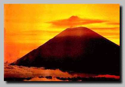
Krakatau (Indonesian: Krakatau), often mispelled Krakatoa, is a volcanic island made of a'a lava located in South Lampung region in the Sunda Strait between the islands of Java and Sumatra in Indonesia. The name is used for the island group, the main island (also called Rakata), and the volcano as a whole. The island exploded in 1883, killing approximately 40,000 people, although some estimates put the death toll much higher. The explosion is still considered to be the loudest sound ever heard in modern history, with reports of it being heard nearly 3,000 miles from its point of origin. The shock wave from the explosion was recorded on barographs around the globe.

In the early time Krakatau estimated was a volcano with 2000 M in height. The catastrophic eruption destroyed the volcano and remained 3 islands i.e. Rakata, sertung and Panjang. The renewed activity was started at Rakata, and an island of strato volcano was built up with diameter of approximately 5 Km and 800 M high. After its dormancy, next activity was shifted come into existence with the height approximately 456 and 120 M above sea level. In 1883, the 3 summits (Rakata, Danan & Perbuatan) was erupted and leaving a piece of small part of Rakata. The boom of explosion causing tremors and was heard as far as Singapore and Australia. The wave washed everything away around volcano. The volcanic ash was blown in to the atmosphere, as much as 4 cubic miles. In 1927 the new activity was occurred and then Anak Krakatau existed in to being. Now Anak Krakatau has reached 250 meters above sea level. Anak Krakatau still active with its gush of steam and smoke, make it spectacular view.

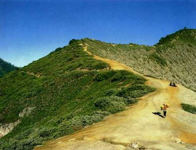
Today we can come and step our foot on it searching closely the minerals (volcanic bomb, lava, lapel) from the bottom of the earth which were thrown up through its crater. Krakatau and its terrific eruption, which is recorded in the history, now has invites every one to come and see for science as well as for pleasure. The way to get there is from Canti located in Kalianda about an hour driving from Bandar Lampung, and the boats will take to the Karakatau area. Near by the Krakatau there are Sebuku and Sabesi Island as for stopover and staying over night. It is only taken one and half-hour from Canti. [source : Krakatau Tourism]

See The Dangerous Beauty


Thursday, November 4, 2010

Mount Merapi

Mount Merapi, Gunung Merapi (literally Mountain of Fire in Indonesian/Javanese), is a conical volcano located on the border between Central Java and Yogyakarta, Indonesia. It is the most active volcano in Indonesia and has erupted regularly since 1548. It is very close to the city of Yogyakarta, and thousands of people live on the flanks of the volcano, with villages as high as 1700 m above sea level.

Merapi volcano is one of the world's most active and dangerous volcanoes. It contains an active lava dome, which regularly produces pyroclastic flows. It has been active for 10,000 years. This fire mountain remains one of the most active and dangerous volcanoes in the world. It can be seen from its name; Merapi from Javanese word 'Meru' means 'Mountain' and 'Api' means 'fire'. The internally giant smoking Mount Merapi is one of the active volcanoes that found in Indonesia. It is presenting its peaceful and sleepy dense forest.

Beyond this, there lies a vast deserted land with its deep and steep valley spread out among the mountain hills where sibilant pines and wild grass make out the dominating vegetation, all presents a very exciting panorama. Merapi is located about 30 km north of Yogyakarta, a city with a population of 500,000. It is tall (2.8 km or 1.7 miles high) and has steep slopes. The top of the volcano sometimes has a normal crater, but usually a broad mound of pasty lava (called a dome) fills the crater. The dome plugs up the volcano, making it difficult for other lava and ash to escape. A broad gouge funnels lava and ash flows from the top of Merapi to the south slopes of the volcano. [source : Merapi]

See The Dangerous Beauty


Thursday, September 23, 2010

Beautiful Ijen Crater Lake

Ijen Crater (Indonesian : Kawah Ijen) is the biggest crater lake in Java. The sulfur crater lake lies between a natural dams of deeply etched rock. It is 200 meters deep and contains about 36 million cubic meters of steaming acid water,  which is about 20 kilometers wide, shrouded in a smelling swirling sulfur cloud. Inside the crater the different color and size of stones are found. Indeed the crater of Ijen is beautiful garden of stone as well.

Ijen Plateau lies in the centre of Ijen-Merapi Malang Reserve, which extends over much of the mountainous region directly west of Banyuwangi and borders on the Baluran National Park in the northeast. As at Mt. Bromo, the caldera is best viewed from the air. Fortunately, almost all commercial flights operating between Denpasar - Surabaya, Yogyakarta or Jakarta usually fly, if not directly over, then close by Ijen plateau, where the seemingly luminous blue/green crater lake forms an unmistakable landmark. It is beautiful scenery and located about 32 km to the north west of Banyuwangi.

The principal attraction at Ijen is the large Crater Lake that has much sulfur, which lies hidden between sheer walls of deeply furrowed rock at more than 200 meters. The Ijen crater itself lies at approximately 2,300 meters above sea level. It forms a twin volcano with the now extinct Mount Merapi. The enormous Crater Lake, which is 200 meters deep and covers an area of more than meters, a million square meters, contains about 36 million cubic meters of steaming, acid water.

Ijen crater shows a special type of volcanic feature common to Indonesia, about 1 kilometer in diameter and 175 meters deep. The floor is covered completely by a warm lake, milky blue green in colours held back by a dam built many years ago by the Dutch, in order to keep the hot, mineral laden water from raining the crop lands below.

The crater can be reached from either the east or the west by any kinds of vehicles, but the second part of the trip covers distance 3 km on foot (jungle track). However, the latter is more popular approach, since the climb from the road's end to the edge of the lake is only one and a half hours. And a walk around the lake takes a full day.

The temperature drops at night, near the crater rim it can fall to about 5° Celsius. The road ends at Jampit, where very basic shelter is available. It is also possible to sleep in the old vulcanology station further up the hill, now used by sulfur collectors, but permission must be obtained in advance.

The view of sulfur miners who climb and go down to the crater is also amazing. A man puts about 10 kg of yellowish stone in to his basket, before he descends the mountain slope to sell his load, carrying the same basket, going in the same direction, digging the same mineral. It is the natural picture that can be seen everyday. The sulfur is transported entirely on foot. In the past, horses were used but they were found to be less practical on the hazardous terrain. Today, the mine yields nine to twelve tons of sulfur per day.

Men carry individual loads of up to 70 kg, often barefooted, up to the rim of crater and then 17 km down the mountainside to a factory near Banyuwangi. The porters are paid by weight. The most important advice if you are traveling to Ijen is: "If you lose your way, just look out for the sulfur trail". The meaning was clear, since a continuous flow of two ways traffic, carrying the sulfur down the mountainside from the lake and trudging up again to re-load, had left a yellow trail on the well-worn path. The best time for seeing Ijen Crater is at 8 to 9 am. [source : Ijen]

See The Beauty


Monday, July 26, 2010

Mount Semeru

Semeru, or Mount Semeru (Indonesian: Gunung Semeru), is a volcano located in East Java, Indonesia. It is the highest mountain on the island of Java. The stratovolcano is also known as Mahameru, meaning 'The Great Mountain. Maars containing crater lakes have formed along a line through the summit of the volcano. It was formed south of the overlapping Ajek-ajek and Jambagan calderas. Semeru lies at the south end of the Tengger Volcanic Complex.
 
Semeru's eruptive history is extensive. Since 1818, at least 55 eruptions have been recorded (10 of which resulted in fatalities) consisting of both lava flows and pyroclastic flows. All historical eruptions have had a VEI of 2 or 3.

Semeru has been in a state of near-constant eruption from 1967 to the present. At times, small eruptions happen every 20 minutes or so.


Semeru is regularly climbed by tourists, usually starting from the village of Ranu Pane to the north, but though non-technical it can be dangerous. Soe Hok Gie, an Indonesian political activist of the 1960s died in 1969 from inhaling poisonous gases while hiking on Mount Semeru. [source : Semeru]

See The Beauty