Showing posts with label Crater. Show all posts

Friday, October 8, 2010

Kawah Putih Ciwidey : Beautiful White Crater Lake

Kawah Putih (English : white crater) Ciwidey located in approximately 46 km southern Bandung city, West Java, Indonesia. It formed by the active volcano of Mount Patuha, situated 2,343 meters above sea level. This crater was formed between the 10th to 12th centuries by the eruption of Mount Patuha.

Kawah Putih Ciwidey seems looks like a lake surrounded by mountains. The water is warm and has a high sulfur content, and the sunshine frequently change the color of the water from milky white into bluish green. But commonly the water colored white with a high volume smoking haze above land surface. Beside the crater, sand and stone around it also dominated in white, that's why it named with Kawah Putih (white crater). It's a stunning natural attraction.

At Kawah Putih, you can also find a number of stalls selling bandrek, a traditional Sundanese beverage made from ginger and palm brown sugar. This beverage is highly suitable for cold weather, as drinking bandrek will warm your body.

See The Beauty


Thursday, September 23, 2010

Beautiful Ijen Crater Lake

Ijen Crater (Indonesian : Kawah Ijen) is the biggest crater lake in Java. The sulfur crater lake lies between a natural dams of deeply etched rock. It is 200 meters deep and contains about 36 million cubic meters of steaming acid water,  which is about 20 kilometers wide, shrouded in a smelling swirling sulfur cloud. Inside the crater the different color and size of stones are found. Indeed the crater of Ijen is beautiful garden of stone as well.

Ijen Plateau lies in the centre of Ijen-Merapi Malang Reserve, which extends over much of the mountainous region directly west of Banyuwangi and borders on the Baluran National Park in the northeast. As at Mt. Bromo, the caldera is best viewed from the air. Fortunately, almost all commercial flights operating between Denpasar - Surabaya, Yogyakarta or Jakarta usually fly, if not directly over, then close by Ijen plateau, where the seemingly luminous blue/green crater lake forms an unmistakable landmark. It is beautiful scenery and located about 32 km to the north west of Banyuwangi.

The principal attraction at Ijen is the large Crater Lake that has much sulfur, which lies hidden between sheer walls of deeply furrowed rock at more than 200 meters. The Ijen crater itself lies at approximately 2,300 meters above sea level. It forms a twin volcano with the now extinct Mount Merapi. The enormous Crater Lake, which is 200 meters deep and covers an area of more than meters, a million square meters, contains about 36 million cubic meters of steaming, acid water.

Ijen crater shows a special type of volcanic feature common to Indonesia, about 1 kilometer in diameter and 175 meters deep. The floor is covered completely by a warm lake, milky blue green in colours held back by a dam built many years ago by the Dutch, in order to keep the hot, mineral laden water from raining the crop lands below.

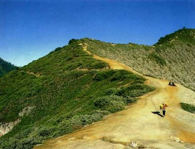
The crater can be reached from either the east or the west by any kinds of vehicles, but the second part of the trip covers distance 3 km on foot (jungle track). However, the latter is more popular approach, since the climb from the road's end to the edge of the lake is only one and a half hours. And a walk around the lake takes a full day.

The temperature drops at night, near the crater rim it can fall to about 5° Celsius. The road ends at Jampit, where very basic shelter is available. It is also possible to sleep in the old vulcanology station further up the hill, now used by sulfur collectors, but permission must be obtained in advance.

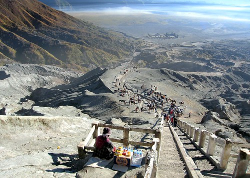
The view of sulfur miners who climb and go down to the crater is also amazing. A man puts about 10 kg of yellowish stone in to his basket, before he descends the mountain slope to sell his load, carrying the same basket, going in the same direction, digging the same mineral. It is the natural picture that can be seen everyday. The sulfur is transported entirely on foot. In the past, horses were used but they were found to be less practical on the hazardous terrain. Today, the mine yields nine to twelve tons of sulfur per day.

Men carry individual loads of up to 70 kg, often barefooted, up to the rim of crater and then 17 km down the mountainside to a factory near Banyuwangi. The porters are paid by weight. The most important advice if you are traveling to Ijen is: "If you lose your way, just look out for the sulfur trail". The meaning was clear, since a continuous flow of two ways traffic, carrying the sulfur down the mountainside from the lake and trudging up again to re-load, had left a yellow trail on the well-worn path. The best time for seeing Ijen Crater is at 8 to 9 am. [source : Ijen]

See The Beauty


Thursday, May 20, 2010

Mount Tambora

Mount Tambora (or Tamboro) is an active stratovolcano, also known as a composite volcano, on the island of Sumbawa, Indonesia. Sumbawa is flanked both to the north and south by oceanic crust, and Tambora was formed by the active subduction zone beneath it. This raised Mount Tambora as high as 4,300 m (14,100 ft), making it formerly one of the tallest peaks in the Indonesian archipelago. After a large magma chamber inside the mountain filled over the course of several decades, volcanic activity reached a historic climax in the super-colossal eruption of April 1815.

The 1815 eruption is rated 7 on the Volcanic Explosivity Index, the only such eruption since the Lake Taupo eruption in about 180 AD. With an estimated ejecta volume of 160 cubic kilometers, Tambora's 1815 outburst was the largest volcanic eruption in recorded history. The explosion was heard on Sumatra island (more than 2,000 km (1,200 mi) away). Heavy volcanic ash falls were observed as far away as Borneo, Sulawesi, Java and Maluku islands. Most deaths from the eruption were from starvation and disease, as the eruptive fallout ruined agricultural productivity in the local region. The death toll was at least 71,000 people (the most deadly eruption in recorded history), of whom 11,000–12,000 were killed directly by the eruption; the often-cited figure of 92,000 people killed is believed to be overestimated. The eruption created global climate anomalies that included the phenomenon known as "volcanic winter": 1816 became known as the "Year Without a Summer" because of the effect on North American and European weather. Agricultural crops failed and livestock died in much of the Northern Hemisphere, resulting in the worst famine of the 19th century.

During an excavation in 2004, a team of archaeologists discovered cultural remains buried by the 1815 eruption. They were kept intact beneath the 3 m (9.8 ft) deep pyroclastic deposits. At the site, dubbed the Pompeii of the East, the artifacts were preserved in the positions they had occupied in 1815.

This is a difficult mountain to reach let alone climb. Few non-Indonesian visitors ever make it to this remote corner of northern Sumbawa and far fewer still to the top of mighty Mount Tambora. 
 
It is possible to climb Tambora but be warned - it is not a stroll in the park. You have to be physically very fit and be ready for some discomfort and danger. Very few Indonesians, and far fewer foreigners, ever make it to this out of the way place. Since 2004 when records began to be kept by K-PATA - Kelompok Pencinta Alam Tambora (The Tambora Nature Lovers Group), only about 50 people per year have made the trip. For example in the first six months of 2009 only three groups climbed the mountain -a group of nine Indonesians, a Frenchman and one Australian.

To reach Tambora you need to get to the village of Pancasila. It is problematic if you want to do this in one day from Sumbawa Besar. If you want to try, take the Sumbawa Besar/Dompu bus very early in the morning and tell the driver you want to go to Calabai/Pancasila Mau mendaki Tambora (I want to climb Tambora). He will drop you after four to five hours at the tee-intersection from where the road to the right goes to Dompu (about 20 km away) and the road to the left takes you to Calabai. There are regular buses to Calabai but the road is very bad and the 110 km trip takes 4-5 hours. From Calabai you have to take an ojek (back of a motorcycle) to Pancasila.

At Pancasila you will be directed to K-Pata's headquarters. The manager is Saiful and his wife is Irma. They will give you a room to stay, feed you well and organise guides. A fair price for food and lodging is Rp 100,000 per night and the guides require Rp 200,000 per day. This is a very reasonable fee considering the amount of work they are required to do on the trip, the nature of the terrain and the length of the walk.

The walk is through virgin jungle. It is incredibly thick in parts and a lot of parang work is required. You will walk for hours along an almost indecipherable trail. 

for further details visit http://wikitravel.org/en/Mount_Tambora

See The Beauty


Monday, May 17, 2010

Mount Bromo


Mount Bromo (Indonesian: Gunung Bromo), is an active volcano and part of the Tengger massif, in East Java, Indonesia. At 2,329 metres (7,641 ft) it is not the highest peak of the massif, but is the most well known. The massif area is one of the most visited tourist attractions in East Java, Indonesia. The volcano belongs to the Bromo Tengger Semeru National Park.

Mount Bromo sits in the middle of a vast plain called the Sand Sea (Indonesian: Lautan Pasir), a protected nature reserve since 1919. The typical way to visit Mount Bromo is from the nearby mountain village of Cemoro Lawang. From there it is possible to walk to the volcano in about 45 minutes, but it is also possible to take an organised jeep tour, which includes a stop at the viewpoint on Mount Penanjakan (2,270 meters) (Indonesian: Gunung Penanjakan). The best views from Mount Bromo to the Sand Sea below and the surrounding volcanoes are at sunrise. The viewpoint on Mount Penanjakan can also be reached on foot in about two hours. From inside the caldera, sulfur is collected by workers.

If a landscape was ever needed to demonstrate the meaning of the phrase desolate beauty, then this is surely it. Rugged, barren volcanic peaks, gravel plains and that sea of sand. Truly unworldly. And the best natural attractive of Bromo is watching sunrise surround its caldera. It is a stunning moment.

The park also includes large areas which are very lush and green fed by rivers from the high tops. The medium elevations are clad with much thinner forest before this gives way to the barren plateau and peaks.

It's other attractiveness, is that volcano is a place of a final ritual ceremony called kasada of Tengger Tribe that is reprensented by throwing farming product like fruits and grain onto Mount Bromo crater. This annual ceremony has always attract tourists to see it.

source : http://en.wikipedia.org/wiki/Mount_Bromo

See The Beauty 

 Smoke on The Blue Sky

 Waiting The Moment

Climb The Stairs

Across The Sand Sea